';

So Many Things to See in Northern California!

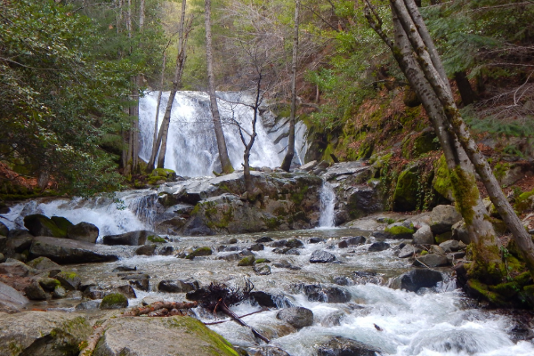
The Shasta Cascade Region is your gateway to outdoor adventure. With towering mountains, pristine lakes and rivers, cascading waterfalls, seven National Forests, eight National and State Parks, and thousands of acres of wilderness, the recreational opportunities are endless. Travel along one of the region's Scenic Byways to experience the area's breathtaking scenery and discover historical points of interest. Make life-long memories with friends and family experiencing a variety of activities and attractions that you can only find throughout the Shasta Cascade Region. Spend a weekend relaxing on the lake houseboating, hiking a volcano, fly fishing in a world class river, along with a variety of other activities that are waiting to be experienced.

+ Filter Results
Prev56789Next
2866
14412 Kennedy Memorial Drive
Whiskeytown, CA 96095
530-246-1225
At over 138 feet tall, Boulder Creek Falls was thought to be the tallest waterfall in Whiskeytown National Park until the re-discovery of Whiskeytown Falls in 2004. With three cascades down a canyon covered in moss and ferns, you'll feel like you're in a dream.Driving Time: 15 mins / 9.44 miles from ReddingDistance: 2.25 miles (one way)Difficulty: Moderate
Shasta County
5554
Boundary Trail - Kangaroo Segment National Recreation Trail
CA 0
(530) 493-1718
This trail provides spectacular views of the Red Butte and surrounding mountains. Southern exposure near the ridge top, good views, rough country, lots of rock and brush.
Siskiyou County
2167
14412 Kennedy Memorial Drive
Whiskeytown, CA 96095
530-246-1225
Brandy Creek Falls is one of the widest waterfalls in Whiskeytown National Park with five cascades that rush over the granite rock of the canyon. Here you will find the unique Indian Rhubarb displaying bright colors in spring and fall. This trail connects to Rich Gulch Trail. This waterfall is accessible by trail. A map of the trail to Brandy Creek Falls is available at the Whiskeytown Visitor Center. Driving Time: 15 mins/9.44 miles from…
Shasta County
2831
21820 Lassen National Park Hwy
Mineral, CA 96063
530-595-4444
From this trail a vast area of the surrounding landscape as well as nearby park landmarks are visible. At 10,457 feet, Lassen Peak has the premier views of any to be had within the park. However, the vistas from the summit of Lassen Park’s second highest point are nearly as wonderful.
Tehama County
5388
21820 Lassen National Park Hwy
Mineral, CA 96063
For sheer beauty and rugged mountain scenery the Brokeoff trail is one of the best in Lassen. The trail climbs steadily through open meadows and forest for two miles and then through scattered hemlocks and finally above timberline to the top. At the west end of the mountain just before the last half mile of the climb, there is a good view of Mt. Shasta. From the top of the mountain there are good views…
Tehama County
2853
Snowmobiling in the Shasta Cascades
39696 Hwy. 70
Quincy, CA 95971
530-238-0555
This is the main route offering connections to many of the loop trails and provides access to the resorts at Bucks Lake. This trail begins at the Bucks Summit Staging area and ends at the Four Trees Warming Hut.  This is the main route offering connections to many of the loop trails and provides access to the resorts at Bucks Lake.  
Plumas County
5396
Redding, CA 0
This is a great, short, intermediate ride that could be turned into a longer ride by connecting on to the River Trail. Dogs ok on leash. Trail goes downhill toward the River Trail.Distance: 1.23 Miles (From Sacramento River Trail)Difficulty: Intermediate
Shasta County
5392
21820 Lassen National Park Hwy
Mineral, CA 96063
Bumpass Hell was named after an early settler who severely burned a leg after falling into a boiling pool. The hydro thermal features can be reached today from a well-marked 1.5 mile trail that starts from a parking area opposite Lake Helen. A visit to Lassen is not complete without a stop at Bumpass Hell.The trail is quite easy, though the altitude (8,000 feet) can make the trail seem moderately difficult. Hiking boots are recommended…
Tehama County
2832
204 West Alma Street
Mt. Shasta, CA 96067
530-926-4511
Snowshoers of all abilities can enjoy this easy route along the pleasantly graded and easily discernible extension of the highway to Panther Meadow. Wandering in and out of red fir forest, the route offers exceptional scenery along the way.
Siskiyou County
2152
Castella, CA 96017
530-926-4511
This waterfall makes it's appearance every year in late winter and early spring. It's source is a small granite basin where Burstarse Creek drains. This waterfall is moderately accessible.
Siskiyou County
Prev56789Next
Showing results 61 to 70 of 248
Shasta Cascade Wonderland Association
1699 HWY 273, Anderson, CA 96007 | (P) 530-365-7500
Things to Do | Wine & Dine | Events | Planning | Stay | Regions | Partners | Media | About Us | Contact Us
Website Developed by Drozian Webworks